
High Point Truck Trail – Palomar Divide Trail – High Point Lookout Trail

Distance: 22.1 Miles (+1 mile)
Elevation gained: 4,000′
Time: 8:30
Difficulty: Masochistic
Critters: none to speak of
Pros:
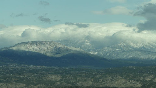
– Epic views of mountains in Riverside, San Diego, Los Angeles, and Orange Counties, including San Gorgonio, San Jacinto, Baldy, Santiago Peak, Cuyamaca Peak, Laguna Mountains, Hot Springs Peak
– Tremendous sense of accomplishment
– Beautiful panoramic view of Palomar Mountain from High Point
Cons:
– LONG
– First two-thirds of the trail is a little monotonous once you’ve acclimated to the tremendous views

Details:
First, let me get this out of the way: OUCH! Not because of the Coulter pine cone shown below, which can prick your hands pretty well. Ouch, because this was a long, LONG hike.

Second, I want to impart a warning to anybody attempting to hike up to High Point. The road from Oak Grove is closed to public use. It is not possible without doing a lot of trespassing to access the trail from that point. The only access point is now the High Point truck trail in Aguanga. If you drive to the gate, about three miles in, this hike will only be 18 miles (only, right?) as opposed to the 22.1 it was for me.

This hike was one of my goals for the early part of the year. I recently updated my year-long goals to expand upon the six-pack of peaks with my self-created (and arbitrarily so) twelve-pack of peaks that starts small-ish with Boney Mountain (3,111′) and ends with San Gorgonio. I included Palomar on the list, coming in at #5 after Wilson, Lukens, Santiago, and Boney. To this point, I have knocked off three items on that list.

This is the longest hike I’ve ever done. My previous was 17 miles. This is also the highest elevation gain I’ve ever attempted. My previous high was 3,600′. I was not expecting this hike, nor was I prepared for it. It’s not a hike I would recommend to anybody other than serious hikers who are looking for ways to punish themselves. To say that it was a challenge, particularly for somebody who is only acclimated comfortably to hikes in the 15 mile range, is an understatement. And yet, as is often the case with this curious hobby, I wouldn’t trade the monotony, the effort, the freezing cold feet, the ice gusts of wind, the swollen ankles, and all the other pain for anything.

Hiking often involves measuring yourself against a challenge. How high can you climb? How many peaks can you bag? How long can you go? How many miles can you walk in a year? In that respect it can be a metaphor in a lot of ways, but in literal terms, you are pushing your body up against an immovable object. At some point, any hiker is going to want to see how far they can go, whether it’s a novice or infrequent hiker trying to tackle a large hill, or a lifelong diehard trying to bag the entire PCT in one summer. I don’t really know why. Perhaps it’s an effort to conquer one’s limitations. Perhaps it is true that on top of every mountain, there lies a longing for an even higher mountain. Perhaps it’s just attaining a sense of accomplishment. Perhaps it’s just something to do. Whatever the case, hikers seek out challenges time and again.

This hike took me from the base of the north side of Palomar Mountain to it’s highest point, uncreatively dubbed “High Point.” The goal is to reach the 67-foot fire lookout tower, which surveys a vast panorama of scenery stretching across most of Southern California. Mountains as far away as Mt. Wilson are visible, and the view includes virtually every major peak in south of the Mojave Desert.
Along the way, you cross a hilly stretch of desert landscape, ascend up to the top of a chaparral covered ridge that features ribbonwood, manzanita, chamise, yerba santa, and several varieties of sage. The bulk of the hike occurs on a relatively flat ridge between the first ascent and the final ascent up the “back” side of Palomar.

After about 6-7 miles on this ridge, you pass through a shallow canyon into a mixed forest of black oak, live oak, cedars, and Douglas firs – the classic mix that dominates palomar. After making a right onto Palomar Divide Road, you soon come to a left to climb the steep hill leading to the fire lookout and summit.

I took this hike the day following a storm, and at this elevation, this storm dumped 6-12 inches of snow at the highest elevations on the hike. At first, hiking in the snow is an enjoyable novelty. Soon, however, it becomes similar to walking long distances on a beach that stretches up a hill. Furthermore, snow tends to melt on your shoes, and if you are not wearing waterproof boots, which I was not, your feet become very wet and very cold. It becomes important to keep moving under these circumstances to avoid hypothermia, since the outside temperature on this day never got above 40 degrees with windchill at the highest levels.

Aside from the reprieve of forest at the top of the mountain and the stunning mountain views (snow covered, today), there is not a lot to recommend about this hike. Chaparral is an enjoyable and beautiful habitat, but for 85% of this hike, the vegetation remains consistently even and unchanging. When these plants weren’t covered in snow, or dripping wet, or covered in ice, they did become monotonous, leaving a desire for more variety in the flora. Furthermore, the hillsides roll gently in that classic SoCal way, but within the hike itself, very little changes, and the going becomes pretty tedious.

The views are the primary recommendation, along with the sense of achievement. However, the views and an easier route are both achievable at a number of other places, so if you’re looking for similar panoramas without having to hike 20+ miles, look into some other options such as the Laguna Mountains, Cuyamaca Peak, Volcan Peak in Julian, and perhaps even Santiago Peak in the Santa Ana Mountains (although, that last is no picnic either).

More than anything though, I will always remember this hike for being the one that pushed me way past what I thought I was capable of. That I completed it at all is a major accomplishment for me, since the prior 17 mile hike was an extremely painful experience that I barely finished. It speaks to how well I have conditioned myself, and it leads me to believe that no hike in the SoCal region (with the proper preparation) is beyond my capability.

But in spite of all the views, the one site that was sweetest behold on the entire hike was this:

A Honda waiting faithfully and patiently for an owner who just wrecked his lower body and wanted nothing more than a chair to sit in. Blessed relief! The rewards of hiking can be awfully strange sometimes.
February Miles: 64.2
Year-to-Date: 190
