

Hike 1:Scott’s Cabin Trail – Cedar Trail – Doane Valley Trail – Chimney Flat Trail
Hike 2: Observatory Trail
Hike 3: Lopez Canyon Trail
Distance: 4.6, 4.4, 4.4 miles, respectively.
Elevation Gain: 600, 750, negligable
Difficulty: Easy, Moderate, Easy
Time: 2:14, 2:43, 1:57
Critters: 25 mule deer, squirrels, chipmunks, hawks, bluebirds, jays
Pros (Palomar):
– Reasonably easy access to a mixed conifer forest, mountain, and great views.
– Morning light makes this a beautiful place
– Chances of seeing deer here are high
– The Hale telescope is pretty fricking awesome
Pros (Lopez Canyon):
– Beautiful hike through riparian wilderness
– Oasis within urban sprawl
Cons (Palomar):
– Many trails are not well-maintained
– A lot of areas at the observatory are off-limits
– Signs and fences
Cons (Lopez Canyon):
– Aside from the fact that it isn’t Penasquitos Canyon like I had presumed?
– Multiple crossings over a rocky wash
– Trail vanishes after bridge

Two hikes in one blog. I’m wrapping both of these into one because the same mild comedy of errors that I seemed to be creating seeped into both of these hikes. I entered into both with grand ambitions; first, I intended to hike from the Silvercrest parking area in Palomar State Park across Doane Valley, up the crest, through Fry Creek, up the Observatory Trail, past the Observatory, and all the way to High Point. With Lopez Canyon, I was intending to hike the full 10+ miles of Penasquitos Canyon. However, neither hike turned out that way.

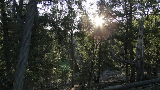
I made it up to Palomar in time to catch the sun rising over mist-filled valleys. The air was cold and crisp, rattling the dead leaves clinging to the black oaks. It was an auspicious morning for a hike, and yet I was out-of-sorts from the beginning. Perhaps it was simple homesickness from the recent move from Agoura Hills to Oceanside. Perhaps it was uncharacteristic loneliness brought on by an unusually large amount of upheaval. Perhaps I was just tired. Perhaps it was all of the above. Whatever the case, I made off in the spirit of duty, if not with an eager spirit of adventure. The thought was that a hike can be a digestive for all of the change I had just undergone. In my stubborn, myopic, and dive-right-in way, I figured I could hike my way through whatever turbulent mental waters that I had waded into. Like always, life found a way to have some fun with me.

I’ve already said a fair amount about Palomar. At 5,000+ feet, it supports a lovely mixed-conifer forest, which provides a welcome oasis from urban development in the way that chaparral covered hills never can. It’s not the Sierras, but nothing is. The morning sunlight made it even more beautiful, in spite of the occasional warts of overdevelopment and the evidence of tree removal due to drout and bark beetles.

The trek to High Point would have racked up a good 14 miles and gained a few thousand feet, creating a nice warm-up for some of the epic hikes I have lined up. I wouldn’t have it that way though, as I came to Doane Valley and wandered among the outdoor school there for a half hour hoping to find the trail to Fry Creek. I checked behind each building, finding nothing. Then, I walked a quarter mile along the Doane Valley trail, also finding nothing. Then, I committed a sin I rarely commit, going off-trail and cutting across with the hopes of intersecting the trail. Nothing. All I found was fences, signs, and a trail that vanished into the bushes. My ambition even prevented me from enjoying Doane Pond and Doane Valley as the sun started creeping up over the ridge to the south.


Dispirited, I turned back to the car, and headed off to the Fry Creek campsite, hoping that I could take the Fry Creek loop, and then meet up with the Observatory Trail and walk up to the gleaming white domes of the telescopes. I found both the Fry Creek and the Observatory campgrounds closed. I also found abundant signs demanding that you display your adventure pass, which I still don’t have.

I parked at the Observatory, which does not require an adventure pass, and nosed around for the trail up to High Point. I could see the fire tower on High Point clearly, and new that I could hike there and back in about an hour and a half. I knew there was a trail based on what I could see from google maps. And yet, everywhere I turned, I would see signs advising unauthorized personel not to enter. This place is not for you, the fences and bars and signs all say. Caltech owns the land, and Caltech does not want you farting around its multi-million dollar, historically and scientifically significant telescopes.
You can’t really blame them, and yet, I was getting into that mindset where I was grumbling and huffing about signs and rules and regulations, and about how this was just spoiling my day in the woods and grumble grumble grumble. I was encroaching upon a “life’s-not-fair” teenage tantrum.

My 14 mile hike had shrunk to a modest 4.6 miles, and I was determined to scratch 9 if I could help it. I wandered around the observatory, getting lost and running into more and more fences and signs, until I finally stumbled across the Observatory Trail.

The Observatory Trail winds gently over ridges and down a mild slope until it spits you out at the Observatory Campground. It’s a lovely trail that travels across alternating hot, dry, sparsely vegetated south-facing slopes into cool, damp, heavily forested north-facing slopes, thus illustrating the principal that quantity of water and the quality of light are the queens and the kings of life. The trail also opens up to a view of beautiful Mendenhal Valley, in which a handful of lucky bastards live amongst wide-open mountain meadows, lakes, streams, and forests.
I trudged my way dutifully down the trail and back, briefly pondering a go at the Fry Creek Trail. However, I had hit 9 miles, and I felt that I was done with hiking for the day. I drove down, still in a bit of a mood and hoping that my sense of humor might come back. All-in-all, it was gorgeous hiking, and all the more gorgeous considering that Palomar is an hour away from Oceanside. However, the mind decided to dominate this go around, leaving me unsatisfied, unsettled, and unfulfilled.
Lopez Canyon

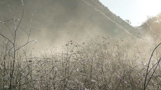
Note how that does not say “Penasquitos Canyon.” Both canyons lie in the middle of a huge stretch of suburban sprawl between Del Mar, La Jolla, and Carmel Valley. Torrey Pines Nature Preserve sits a few miles to the west on sandstone bluffs overlooking the Pacifc. Both canyons lie nestled inbetween housing tracts and office buildings. Thoughtfully protected by the Bureau of Land Management, they represent a respite from the urban jungle. Even though traffic sounds never really escape the ear, and building are visibile throughout the bulk of the hike, both canyons are cool, damp refuges filled with riparian wilderness that is lovely to behold, especially in the early morning hours.

I pulled into the parking lot and set off at a brisk pace with coffee in hand. It was a cold morning, and my breath was making pillowy clouds that trailed off behind me. I felt refreshed and invigorated, determined to forget my frustrations from Palomar and knock off an easy 11 miles and be back in time to kiss Kelly before she left for work. I wended through willows with fresh catkins blossoming forward. The grass was somewhere between icy and dewy. The site of buildings and the sound of nearby Sorrento Valley Road didn’t even bother me as the morning was shaping up to be absolutely beautiful.

I passed under a bridge, and, suddenly, the trail disappeared for a bit. Previously, the trail had vanished into a wash, through which I had to cross while keeping the eyes peeled for the resumption of the trail. However, this time, no trail presented itself. I crossed the wash, which kept growing wider, and then passed through some chaparral, to what looked liked a path leading up the side of the hill. I climbed, higher and higher, hoping to glimpse a place where I might join the trail. This was Penasquites Canyon, afterall, and I knew that it was popular and received a lot of use. I couldn’t understand why it would be so hard to keep the trail.

It finally dawned on me that I had gotten lost. It turns out I had wandered up Lopez Canyon, Penasquitos’ smaller, wilder little brother. The canyon receives much less visitation, despite the shared parking lot.
Now, I rarely get lost, whether hiking or in driving around. I spend a lot of time studying maps before a hike and during a hike, and I also make a point of orienting myself to landmarks and keeping a general idea of where the twists and turns are taking me in relation to north, south, east, and west. And here I was, lost down a canyon in the middle of San Diego. I couldn’t really be that much of a dunce, could I?
Life has a way of making me feel like a dunce when I most need to. I was blue, unsettled, and grumpy because I couldn’t have my way at a state park that shares boundaries with a lot of private land. I had gotten lost in a place where I had no business getting lost. It had all happened mainly because I was so preoccupied with myself that I forgot to focus on putting one step in front of the other.
Hiking is simply the process of putting one foot in front of the other toward and arbitrarily selected direction. Like a vacation or a the pursuit of a degree or a business venture or a conversation, the destination is nearly irrelevant – merely a point B tied to a point A by a thread of experience. All that you should expect of yourself on a hike, long or short, is that you be mindful of each step and experience what is there to experience. Sometimes it is a process within you. Sometimes it is a song stuck in your head that is there for no explicable reason. Sometimes it is silence and vastness, and sometimes it is just the pleasure of feeling your muscles conracting.
However, when you lose your mindfulness, you get lost on trails. You get angry at the flaws inherent in any moment. You feel disappointment and a sense of being unsettled. You get in a cranky mood and think that you should have stayed at home. Occasionally, yes, you should have stayed at home, but when you don’t, the lesson is to take what is there in front of you, regardless of the flaws. A 14 miler that becomes a 4.6 miler can be every bit as beautiful. And why not when it features fir trees, 25 deer, light shining through oaks, a still pond reflecting a rising sun, and a sleeping valley. Without the awe and the wonder and mindfulness, it is all just empty motions.

February: 13.4 miles
Year-to-Date: 137.4 miles
