
Haines Canyon Road/Motorway/Trail – Rim of the Valley Road

Distance: 11.8 Miles (11.4 if you don’t go the wrong way.)
Elevation gain: 3,200′
Difficulty: Moderately Strenuous
Time: 4 hours, 34 minutes
Critters: quail
How to Get There: Take the 405 north to the 118 East. Transition to the 210 East. Exit Sunland Ave, and make a left on Foothill Blvd. Make a left on Haines Canyon Ave., then a left on Day St., followed by another left on Haines Canyon Ave. when it resumes. Park before the locked gate and well away from the no parking signs.
Pros:
- Ridiculous views of Los Angeles, San Fernando Valley, the Ocean, and, when you summit, Big Tujunga Canyon
- Good training for anybody looking to climb some mountains
Cons:
- Thoroughly bbq’d by the Station Fire, this trail supports very little in the way of trees. I will be frank; this is not a pretty trail.
- A lot of exposure.
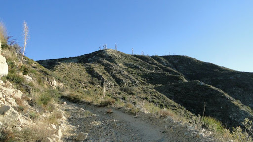
- Antenna installations on the top make the peak less of a peak and more of a compound.
- The weather has to be right for this hike. Otherwise, you’re fighting some gnarly Santa Ana’s, choking on smog, or sweating your brains out.

This one has been on my list for some time. Mt. Lukens looms over the San Fernando Valley, hardly distinct from the solid wall of beige slopes that make up the western wall of the San Gabriel Mountains. And yet, it is still the highest point in the city of Los Angeles to the tune of 5,074 feet. I knew that it would not be a pretty hike. I knew there would be no trees. I knew there would be little shade. I knew that an anti-climactic antenna compound awaited me at the summit, and I knew that it would be difficult. And still, I was determined to do it.Aside from the views, which are brilliant, I knew that this hike would be a measuring stick that would tell me how far I need to go and how hard I would need to work to do the Grand Canyon. It rises 3200 feet in a little over 5 miles, doing so with very little shade. Those are pretty similar conditions to what I would encounter in the Grand Canyon. Granted, the Canyon is at a higher elevation, and the slope is steeper in many places, but gaining that kind of elevation in that distance isn’t too far off of what I’m likely to encounter.
I hit the trail at 6:10 am. I originally intended to do a loop going up the backside of the mountain and coming down the front. However, due to the Station Fire, which thoroughly incinerated Mt. Lukens and the surrounding environs, the backside trail is overgrown and largely impassable. Since it was still pretty dark, I took the front side up, which I would highly recommend if you do this hike – and I’m not sure I would recommend doing this hike unless you want to trudge up a massive slope.
Once you ascend out of Haines Canyon, a view opens up towards the San Gabriel Valley on the left hand and the San Fernando Valley on the other. This view will stay with you for the bulk of the hike, disappearing only when the switchbacks take you back into the upper reaches of Haines Canyon and away from the south slope of Lukens. It definitely helps to have an ever-expanding view of Los Angeles to take your mind off of that burning sensation in your hamstrings.

Gradually, the summit gets closer, the switchbacks climb higher, and the view gets clearer. Finally, the trail bends up and around the top of the mountain, opening up a fairly stunning view of Big Tujunga Canyon and the San Gabriel Mountains, soaking in the sun. This whole area was scorched by the Station Fire, and it still looks pretty barren. Yet, the topography is still lovely in a stark, dramatic sort of way.

Finally, the trail, which is now a full-fledged fire road, spits you out unceremoniously at the summit where you I shared a meal of cold pasta and eggs with 50-foot radar antennae with warnings about over exposure to radio emissions. Those ominous forebodings aside, the view was pretty spectacular, even if the Santa Anas were blowing cold air through my clothing with extreme enthusiasm. I enjoyed some preposterous views of the entirety of Los Angeles – yes, the whole damn messy, overcrowded thing – without a soul around me.

I also got a nice view of Mt. Wilson to the east, which I just climbed a couple of weeks ago. Likewise, I could see Santiago Peak to the south (I’ll climb that one in February), Catalina and Palos Verdes to the south, the Santa Monicas, with Saddle Peak, Castro, and Boney forming prominent bumps in the southwest, the Los Padres Mountains in the west, and, believe it or not, Palomar Mountain to the extreme southeast. Yes, it is a spectacular view. And it is one of those views to which pictures cannot possibly do any justice.

Even if this hike is really just a good ass kicking without much in the way of flora or fauna, I still enjoyed it thoroughly. Best of all, I left feeling pleasantly tired, but neither exhausted nor in pain. The hard work is paying off, my endurance is greater, and my body is getting stronger. Provided I use the same steady, unhurried pace I used on this hike and the last hike, I don’t think it’s out of the question to handle greater than 15 miles or greater than 4,000 feet of gain at this point. That covers most of the major peaks I intend to climb, and that also covers the most difficult stretch of hiking I’m likely to encounter in the Grand Canyon (the North Kaibab trail ascending the north rim). And there is definitely something to be said for eating cold pasta while sitting 4,000 feet above the 10 or so million people who live in the greater Los Angeles area.
January: 124 Miles
Year-to-Date: 124 Miles
