
Big Laguna Trail – Pacific Crest Trail – Noble Canyon Trail – Sunrise Trail
Distance: 12 Miles (approximately)
Elevation gain: 900 feet
Difficulty: Moderately Strenuous
Time: 4 hours, 45 minutes
Critters: hawks, rabbits, squirrels, bluebirds
You Should Know: The Lagunas are part of Cleveland National Forest, and you will need an Adventure Pass to park here.
Pros:
- Expansive desert views
- Relatively flat as far as mountain hiking goes
- Un-spoiled pine and oak forests
- Sunny, lake-filled meadows
- Very easy to swing by Julian for pie afterward
Cons:
- Popular with mountain bikers, some of whom had bad trail etiquette
- Fairly long drive from San Diego (better as a full-day trip or two-day camping trip)
- Slightly confusing trail markers.
On Friday, January 20th, I woke up at 5:00 am and took the nearly hour and a half drive south and east (from San Marcos) to the Laguna Mountains. The Laguna Mountains are part of the peninsular range that stretches from the San Jacinto mountains down into Mexico, which includes Agua Tibia Wilderness, Palomar Mountain, Warner Springs, Julian, and Cuyamaca. Somewhat drier due to the Cuyamacas intercepted a good deal of precipitation, the Lagunas also drop away precipitously on the eastern ridge several thousand feet into Anza-Borrego State Park. The top of the mountain consists of a rolling plateau dominated by a large lake-studded meadow from which the mountains take their name – laguna is ‘lake’ in Spanish.
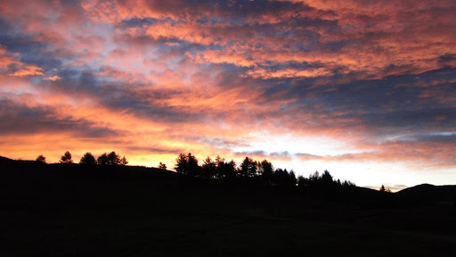
I made it to the top of the mountain at 6:30, which was just in time to watch the clouds catch fire. I stopped the car and snapped a few quick pictures before seeking out the trailhead from which I would begin a wide loop that circles the plateau. This loop can be accessed at several different points – the meadows information kiosk (5.5 miles from I-8), the Desert View picnic area (10.2 miles from I-8), the Big Laguna Trail (10.9 miles), the Foster Point Trail (12.2 miles), and the Noble Canyon Trail (13.5 miles in). Any of these trailhead are great points from which to access the trail. On this day, I chose the Big Laguna Trail (or BLT) since it offered the quickest access to the Pacific Crest Trail (or PCT), from which I might be able to watch the tail-end of the sun rising over the desert.
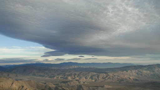
The PCT follows the eastern ridge of the Laguna Mountains, which form a dramatic escarpment that drops several thousand feet into the desert below. From my starting point, the trail wound up and over several mild peaks that each had side trails for additional exploration. In an attempt to get the best desert/sunrise view, I summited Hays Peak, only to find out that the nearby Monument Peak was blocking my view of the sunrise. However, the view I got from here was outstanding as it looked north and east at the Anza-Borrego desert and north toward San Jacinto and San Gorgonio.
I followed the PCT for another 3.5 miles along the ridge with the desert to my right. The trail wound through dense thickets of manzanita before dipping in and out of riparian oak and pine woodland that stood along the headwaters of streams that drain the mountains into the desert below. A fierce, cold wind blew the entire time on this ridge, making the 35 degree morning even colder than it already was. Mild discomfort aside, the PCT made an attractive starting choice since it is reserved for foot traffic only and the desert views make a grand introduction and give this hike the kind of epic scope that made me feel as if I had really gone somewhere, as opposed to the more accessible local hikes. Additionally, the PCT is a dreamy notion for me, traversing from north to south all of the ranges in the western United States. Even a sliver of the whole sounds appealing and romantic.
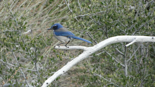
However, the wind and the long switchbacks through manzanita, which I didn’t find as appealing as the pine forest I was expecting, eventually made this section of the trail a little tedious. If I ever have the good fortune (and resources) to travel the PCT, I’ll likely start it in the San Bernadinos or San Gabriels so as to avoid long stretches of chapparal in favor of more forested stretches. At any rate, I soon came the to Noble Canyon Trailhead, which would be my access point to the BLT, but not before a blue bird puffed out his chest for me on the branch of a burnt-out oak tree.
The Noble Canyon trail plunges into oak and pine forest before descending into nearby Noble Canyon. Instead of veering right for that descent, I turned left onto the BLT. This early section of the trail travels through a stretch of forest that was incinerated during the 2003 Cedar Fire. The devestation is pretty severe here with most of the forest thoroughly destroyed and chaparral – mainly ceanothus – taking over. Fortunately, the Lagunas didn’t receive the same level of devestation as the Cuyamacas and the mountains around Julian, and this stretch only lasts for a half mile at most. The trail then rounds a small hill, opening up onto the first view of Laguna Meadow.

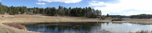
From this point until the end of the trail – about 9 miles worth of hiking – the BLT plunges into an open and airy forest of Jeffrey pine and occasionally black oak while emerging frequently into the vast meadow. At this point, one can opt to take the shorter loop that skirts the meadow toward the Big Laguna Lake (above pictured), or one can choose to climb a small hill on the Sunset Trail, from which one has views to the west, mirroring the viewing opportunities offered by the east-facing PCT. The Sunset Trail climbs some 350 feet to the top of the ridge and passes through a slightly drier, rockier stretch that occasionally opened onto the promised views. The Sunset Trail is also closed to mountain bike traffic, and hikers will have little interferences from the speed demons.
I opted to take the Sunset Trail as I saw a pack of mountain bikers, all dressed in bright neon colors, coming toward me on the Big Laguna Trail. Again, I have no problem with mountain bikers when they are courteous and friendly – not treating the hiker as an unnecessary obstacle – but when a pack of them speeds toward me, and they’re all wearing neon, my choice is made. I spent another three mile stretch in solitude as I crossed the western ridge of the Laguna Plateau before I dropped down into the southern end of Laguna Meadow at the quaintly named “Water in the Woods,” a small, seasonal pond that today was brimming full of half-frozen water and a large community of ducks. This point offers a great place to sit down, eat some food, and enjoy a little rest, and I did so while relishing this view:

Here is where the Big Laguna Trail becomes confusing. One trail spurs due east toward Big Laguna Lake where it eventually loops back to the beginning. Another trail spurs slightly south and then east along the south-eastern edge of the meadow. Both are named the Laguna Trail. Both promise to take you back to the PCT, although some signs say it will, and other signs say it will return you to Noble Canyon. None of the trail markers give any indication of distance to junctions and destinations. The dually-named trails, the inconsistent destination indicators, and the lack of mileage make navigation a bit confusing. For instance, I knew I was on the BLT, and I correctly guessed that if I stayed on the southern spur of the trail, I would eventually get back to the main loop, and therefore my ride home. However, I didn’t know how long it would take, or whether I was going the right way with any certainty. This is fine if you’re familiar with the trails, but nobody wants to have to do guess-work on their first visit to a trail, lest one gets lost or has to backtrack several additional miles. This is a bit of a con as far as this trip is concerned.
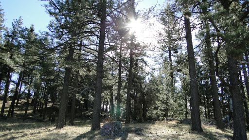
The pro is that, no matter which way you go, you are rewarded with beautiful views from every angle of the meadow to your left and the forest to your right. The open, airy pine forests here are dryer and less dense than the majestic mixed-conifer forests to the north, some as close as Palomar, but the scent of sun-baked pine needles, patches of newly grown grass carpeting the forest floor, gently trickling streams, shafts of light filtering through the needle-laced branches, and whispers of wind through the crowns of the trees make this forest lovely, and often enchanting. Furthermore, as this was a winter hike and all of the grasses and shrubs were dead and brown, I imagine this trail is absolutely gorgeous when Spring kicks in and the grasses turn green and the flowers begin to bloom.

The trail then leaves a beatiful stretch of forest and climbs up a small hill into a mixed pine-oak forest on the way back to the end/start point on S-1. In the winter, with all of the leaves on the ground, the black oaks look a little spooky, and the forest seems a little sad. However, during the spring and fall, I am told that the black oaks are gorgeous, and, again, I am eager to see these mountains in the spring. The trail crosses Huecos Road, a well-maintained dirt road that will lead either to the visitor center on the east side of the road or Laguna Campground near Little and Big Laguna Lakes. Incense cedar makes a brief cameo, offering up the only two non-pine conifers I found on the entire twelve mile loop. After this, it’s a short, sunny stretch dotted with Coulter pines and their massive, head-sized pine cones before you emerge at the trailhead to find the car waiting patiently.

This was a great hike, and it makes a great day away from the city. Furthermore, I took the mountain road home and was able to stop in Julian for a pie, which Kelly and I enjoyed upon my return (no, not the whole thing). I imagine it is beautiful in the Spring, and I intend to come back in April.
January: 97.7 miles
Year-to-Date: 97.7 miles

If only you had included photos of the Julian crumb top apple pie!
Great photos, great write up.