

If you spend any time on social media, you have seen countless list articles highlighting the “BEST HIKES IN (PICK A LOCATION).” They’ve popped up like mushrooms after rainstorms in the last few years, and it seems like everybody is chipping in. I myself have indulged in writing a few of these articles here, here, and here. They do a good job of driving traffic to a website, and for novices, it’s a good way to learn about certain hikes.
Unfortunately, when it comes to San Diego, these lists – and I’m guilty of this too – are often just a collection of the usual suspects that nearly everybody knows about and nearly everybody has hiked. You are bound to see Cowles Mountain, Iron Mountain, Woodson Mountain, Torrey Pines, Penasquitos Canyon, and maybe the occasional nod to Kwaay Paay or Cabrillo National Monument. There are rarely ever any surprises, and given that these lists often don’t add anything new to the average hiker’s repertoire, I’m starting to feel that they’ve outstayed their welcome.
Per reader suggestions, I’ve expanded the list, added driving directions, and have either linked to articles I’ve written about the hike or added information on where you can find the hike inside the 4th edition of Afoot and Afield in San Diego County.
1. High Point, Palomar Mountain

Distance: 13 Miles
Elevation Gain: 3500′
Directions:
Find instruction for this hike on P.186-187 in Afoot and Afield in San Diego County
While everybody is lining up at El Cajon Mountain and Woodson Mountain on Saturday and Sunday, maybe 1 person and a mule deer or two are following the High Point Truck Trail to the highest point in the Palomar Mountains. You’ll find a lookout tower, a jaw-dropping view of the Inland Empire and inland San Diego, groves of deciduous oak trees, impressive stands of old-growth chaparral, and a tough cardio workout. Yes, it’s far away from most people in San Diego, but I guarantee if this was half an hour from the city, there would be a billion people up here every weekend. This is the most spectacular hike that almost nobody ever takes.
2. Border Field State Park
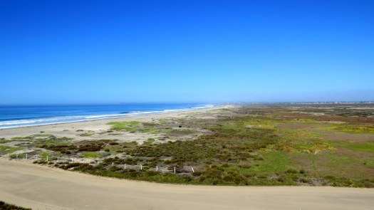
Distance: 5.3 Miles
Elevation Gain: 100′
Directions:
Find instruction for this hike on P.47 in Afoot and Afield in San Diego County
This hike actually is only 30 minutes from the city, and still there are barely any people here. You’re definitely going to see more people here than you will on High Point, but for a trail network that offers access to rare stretch of undeveloped coastline, a wonderful mixture of coastal habitats, and a chance to get up close and personal with the Mexico Border at Friendship Park, there is a shocking lack of visitation here. Part of this is born from confusion about accessibility. Border Field’s road is almost always flooded, so you can’t usually drive to Friendship Park. However, you can hike in from the park’s entrance most days of the year (unless it’s raining hard), and you can enjoy a moderate hike through a variety of habitats to enjoy pristine coastline.
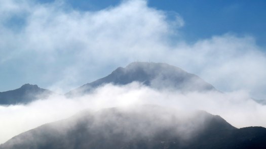
3. Eagle Peak

Distance: 4.3 Miles
Elevation Gain: 1100′
Directions
P. 212 in Afoot and Afield in San Diego County
Yes, people actually do hike this sometimes. My perusal of the summit register revealed that about 4-5 people come up here a week. There may be a few more when the weather is nice. However, the parking lot is always packed with people because. . . . you guessed it: waterfall. Eagle Peak’s visitation suffers from the popularity of nearby Three Sisters Falls. Both trails start from the same trailhead, and while hundreds of people are making their way down the increasingly sketchy trail to the falls, the magnificent views from atop Eagle Peak go largely unseen.
4. Ellie Lane Loop

Distance: 5.8
Elevation Gain: 1500
Directions
This hike is not in the current edition of Afoot and Afield, but you can find a map of it here.
How can a trail between Woodson Mountain and Iron Mountain feel so perpetually neglected? Is it because the trail network is unmarked and a little confusing in spots? Is it because there is no peak to climb, unless you tack on Iron Mountain and make it a 9 mile day? Or is it because the trail climbs and dips a couple of times? It might be all of the above, but the fact is that while the parking lot at Iron Mountain is always full and while there are 50 people waiting to have their picture taken on Potato Chip Rock, there are hardly any people hiking on the Ellie Lane Loop.
5. Guatay Mountain

Distance: 5.8
Elevation Gain: 1900′
Directions:
Modern Hiker
Afoot and Afield in San Diego County, P. 246
You’d think that a peak with gorgeous coastal and mountain views, a challenging cardio workout, and rare plant life might get a bit more attention, but here’s another one that I almost never see people talking about. No, it’s not an easy hike, and it may tend to get overlooked due to its proximity to more popular areas nearby like Cuyamaca and the Laguna Mountains. However, there is a lot to recommend to this hike, not the least of which is a chance to check out the largest and oldest stand of Tecate cypresses, which grow in only three places in San Diego County.
6. Oakoasis

Distance: 2.5
Elevation Gain:450′
Directions:
P. 143 in Afoot and Afield in San Diego County
Perhaps another victim of proximity. The trailhead for serene Oakoasis Open Space Preserve lies directly across Wildcat Canyon Road from “The Hardest Hike in San Diego” at El Capitan Open Space Preserve. While everybody is annihilating their quadriceps, a proportionately scant trickle of hikers enjoys the cool shade of a dense grove of coast live oaks, excellent views over San Vicente Reservoir, and peaceful meadows.
7. The Engelmann Oak Loop

Distance: 5.1 miles
Elevation Gain: 900
Directions:
Modern Hiker
P. 75 in Afoot and Afield in San Diego County
Yes, Daley Ranch gets a ton of visitation, especially on cool weekends when nearly all of Escondido comes out to play. It’s not like you won’t ever see anybody at Engelmann Oak Loop, but in all the times I’ve hiked here, and I hike here a lot, I have seen more than five people on the trail only once. Even then, a lot of those folks are mountain bikers doing a circuit of the park and starting from La Honda Drive. And yet, here are 5 miles of hiking through some of the best oak groves in North County, great views over Valley Center, Palomar Mountain, and Escondido, and stands of rare Engelmann Oaks.
8. Torrey Pines Reserve Extension

Distance: up to 2.4 miles
Elevation Gain: up to 300′
Directions:
Modern Hiker
P. 37 in Afoot and Afield in San Diego County
The extension to the monumentally popular main reserve lies in the middle of a highly-developed, open-space poor region inhabited by people who cannot seem to get enough time in the sun. It protects some of the finest examples of San Diego’s signature tree, the Torrey pine. It offers brilliant sunset views, a dense forest of pines, and a redolent canyon full of aromatic sage-scrub. There may be hundreds of people hiking at the main reserve at any given time. Over at the extension, there might be 5. No, you cannot access the beach, and no there aren’t as many trails. However, this is as lovely a spot as any on the coast, and given the accessibility, it’s a complete mystery to me why people don’t go here more often.
9. Azalea Glen Loop

Distance: 4.1 miles
Elevation Gain: 700′
Directions:
P. 231 in Afoot and Afield
The Azalea Glen Loop was formerly one of the coolest, most beautifully wooded spots in Cuyamaca Rancho State Park. The Cedar Fire took out a lot of the woods, but of all the places in the park, recovery here seems to be most robust, especially along Azalea Creek. On this moderate loop, you’ll visit a reforestation project, a peaceful meadow, a deeply shaded creek, a spring, and good views across the northern half of Cuyamaca Rancho State Park.
10. North and South San Pasqual Trails

Distance: 4.2 for North Trail, 4.4 for South Trail
Elevation Gain: 1400′ for North Trail, 1150 for South Trail
Directions for North Trail:
Directions for South Trail:
Modern Hiker (North Trail only)
P. 87 in Afoot and Afield in San Diego County
This pair of steep, winding trails ascend the north and south walls of Clevenger Canyon. From the top of either side, you’ll get great views of the surrounding region, with the Cuyamaca Mountains and Ramona Valley figuring prominently. The north trail travels through sparser vegetation, but achieves a larger view. The south trail has thicker, more aromatic vegetation and offers the quirky destination of a pair of iron chairs bolted to a large boulder. A welcome mat invites you up the stairs to the chairs, where you can soak in the view in comfort.
11. McGinty Mountain
Distance: 4.6 miles
Elevation Gain: 1400′
Directions
P. 159 in Afoot and Afield in San Diego County
Hiking San Diego County write-up
Given the lack of good peak-bagging options south of Interstate 8 and west of the mountains, you would think that a mountain with views this good would attract more notice. Maybe it’s because it’s tucked into an unassuming location, but I rarely ever hear people talking about this hike. In addition to good views, you’ll also encounter a number of plant species that you wouldn’t normally see on other San Diego hikes. Many of these species are endangered endemics, but the one you won’t fail to notice is Cleveland Sage, which has one of the most powerful and delightful fragrances of any plant in Southern California.
12. Hauser Canyon

Distance: 13.7
Elevation Gain: 2150′
Directions:
P. 285 in Afoot and Afield in San Diego County
This deep canyon on the southern flanks of Morena Butte near Lake Morena County Park is one of the forgotten spots in inland San Diego County. You’ll encounter magnificent oak groves, an abandoned campground that would serve as an excellent spot for overnight camping (permit required, although the NFS website does a terrible job of making the permit easy to find), and you’ll find an old Marine memorial dedicated to Marines who lost their life fighting a 1943 wildfire. The trek is a fairly tough one, but the solitude is divine.

I’ve done five of them (patting myself on the shoulder;-) – the other three moved up on my list. Thanks!
I’m working on a much longer post that ought to give you a lot more to add to your list : )
Cool. Be sure to add the North and South Clevenger Canyon Trails, they are strangely absent!
Good point, and great suggestion. I thought about those, but I wasn’t sure how long to go on a post like this. I’ll throw those in, along with a few other gems that didn’t make the cut.
Yay! 🙂
What about Sunset Cliffs?
Sunset Cliffs is a very popular spot for hiking that doesn’t really fall into this category. It’s a great place to hike though.
I thought I’d see Calcite Mine on here. Everyone has done Domelands, but there are some real gems out in the desert.
I agree that Calcite Mine is a great spot for hiking. However, it is a commonly visited spot, and therefore doesn’t really fall under this post’s theme. Perhaps I should write another one for desert hikes. That will be a very long blog, indeed.
You should include addresses, directions, and gps to these hiking spots. If you do the desert, split mountain and the wind caves off fish creek is a great hike too. Gone plenty of times and never seen more than a dozen people. Always lots in the wash or parking area, but very few on the actual hike or even at the first set of wind caves.
That’s the plan, eventually. The last three routes link to the Modern Hiker articles I wrote. I’m working on articles for the remainder. The info on each hike is readily available, especially if you have Afoot and Afield. I’m also exploring a long term project to make this more of a website than just a blog, and at that point there may be GPS tracks.
EDIT: I added directions, page number to instructions in Afoot and Afield, and links to other sites that describe the hike. When I have time, I’ll link to photo galleries.
Also, I deliberately left the desert out. I can think of a hundred places out there that nobody seems to go. Soon. I’m finishing one book, starting another, trying to fill in a backlog of articles for Modern Hiker, and trying to figure out how to turn this blog into a real website all while working full time. : )
Stonewall Peak and Azalea Springs are some fun hikes that I’ve seen relatively few people on.
Stonewall Peak is definitely a hit with a lot of people, but the Azalea Glen Loop is a great suggestion. I’ll probably expand this blog somewhat since folks are making great suggestions for the list.
Edit: Added.
Ellie Loop is one of my fav’s.
Miners Loop on Black Mountain is also one of my fav’s. Though you’ll see a bunch of people on the trail up to the top of the mountain, you’ll rarely see people (with the exception of bicyclists but only occasionally) on the 2 miles of the Miner’s Loop. I’ve only ever seen other hikers on that trail twice, and I’ve hiked it about 30 times.
You keep referencing Afoot and Afield without mentioning which *edition*; many of us still use the first.
Oh! Yeah, the 4th edition. It’s the most comprehensive, and some of the hikes in the 1st are no longer open.
D’oh! Please ignore my previous comment…I was only looking at the individual hikes and didn’t read the opening paragraphs.
Thanks for adding my suggestions about the trails in San Pasqual! Although, they are called ” Clevenger Canyon North” and ” Clevenger Canyon South” trails. That’s what our signs say. Btw, the parking lot for Clevenger Cyn North remains closed due to vandalism and illegal dumping bit hikers can park along the road for access. Hopefully with tha posibity of increased trail use we can get that lot back open . Thanks again! -Ranger Carey
You bet. And thanks for clearing up what the official names are. I see them referred to both ways.
Shame about the vandalism. I used to commute past that trailhead on a daily basis. I’d stop regularly to walk down to the creek for a bit of a nature break. Are there plans to clean up the graffiti and short-cutting?