

Distance: 17 Miles
Elevation Gained: 4,500′
Difficulty: Strenuous
Time: 7:15
Critters: Marmots, Deer
Pros:
– Easily accessible peak and high country on the west side of the Sierras
– Incredible views of the High Sierras and Great Western Divide
Cons:
– Getting lost and not making it through Giant Forest sucked quite a bit
– Finishing the hike lost and having to walk a mile on asphalt sucked even more
Details:

I have wanted to climb this mountain for a long time. Before I get interested in the six-pack or twelve-pack of peaks; before I got interested in 1,000 miles; before I tackled higher elevations and Sierra high country, there was Alta Peak, looming in my imagination as a challenge yet to be conquered.

On its own, there is nothing particularly daunting about Alta Peak. “Alta” means “high” in Spanish, and yet the peak itself is a dwarf by Eastern Sierra standards. Alta Peak sits at 11,204′, which, while a full 3,200′ lower than Mt. Whitney, is actually 300′ feet lower than Mt. San Gorgonio in Southern California.

By those standards, there’s nothing particularly impressive about Alta Peak. However, there are a number of noteworthy qualities that this peak possesses. First, it is easily accessible. Most other peaks over 10,000 feet in this region requires a multiple-day backpacking trip to access. Even if you see the 17 mile distance and conclude that I am full of crap on the dayhike accessibility, trust me when I say this is a relatively easy accomplishment over the course of a day. Additionally, no other peak aside from Silliman Mountain, which is not easily accessible, juts out from the Great Western Divide, the massive wall of mountains dividing the Sierras into two separate zones, as prominently as Alta. Finally, Alta, being set apart from the rest of the high country, offers tremendous views of both the high country itself, Kaweah Canyon, over which Alta looms several thousands of feet high, and the lower country of the Sierras.

But I don’t care about superlatives. I don’t care about hiking Mt. Whitney just because it’s so tall. I don’t care about hiking Half Dome because it’s so unique. The hikes I enjoy get lodged into my imagination and take on a life of its own. Over the course of the last four visits to the Sequoias, I imagined climbing Alta Peak a number of times, only to be thwarted. Last June, I could not climb the peak because the snow hadn’t melted. Last August, I could not climb the peak because I didn’t have enough time between visiting with two groups of friends on an extended camping trip. This time, however, nothing would stop me.

Perhaps I wouldn’t have made it the first couple times since there is nothing easy about this hike. While it isn’t a brutal, grueling slog offering no respite, it’s certainly no picnic. You gain 4,000 feet over seven miles. This is certainly easier than the 4,600 you gain hiking San Jacinto, but climbing 4,000 feet is never easy. It was probably only once I had proven myself on “lesser” mountains that I could finally take this one. It sounds silly to personify a massive chunk of rock this way, but mountains want to see you humbled. They give nothing away and expect you to earn every foot. And on this hike, there were times where it felt like I was fighting just to move forward.

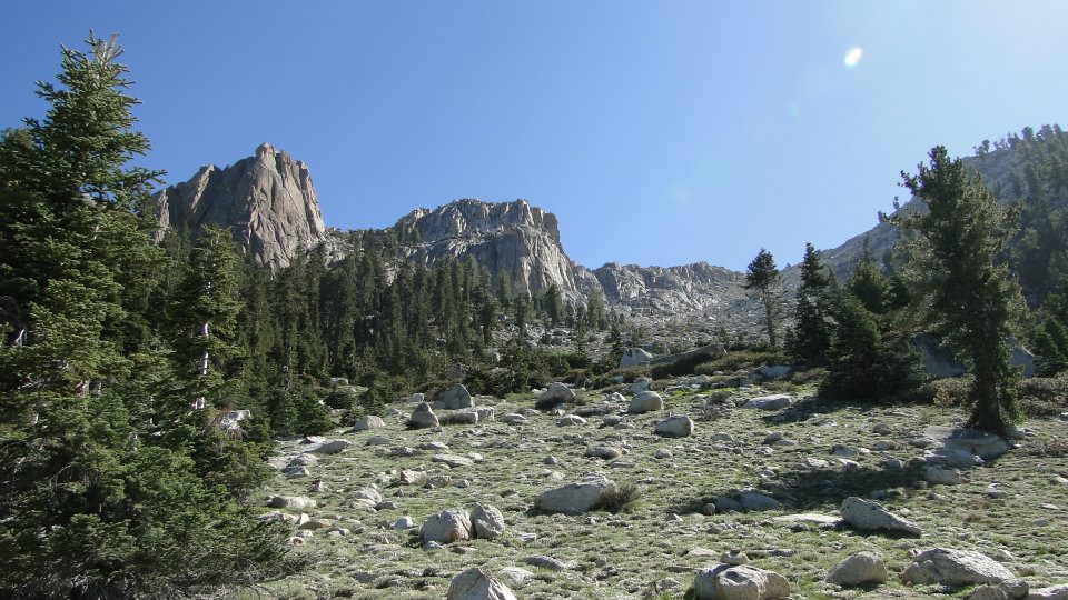
The hike starts from Wolverton, which is a multi-use “village” that offers a number of different trailheads to Giant Forest, the Lakes, Lodgepole, and Alta Peak. It ascends steadily through red fir forest until it reaches a saddle on Panther Gap. On the other side of Panther Gap, the entirety of the Kaweah Valley, including great views of Castle Rock and the Great Western Divide, lays before you.

From Panther Gap, the trail hooks left and continues climbing steadily along the southern flank of the Alta Peak massif, which forms the southern sentinel around Tokopah Valley with Mt. Silliman forming the northern sentinel. The views improve at every step as the terrain becomes dryer, rockier, and less forested. At various points, the trail passes through meadows and trickling streams, creating a nice variety of landscapes to prevent tedium.

After about 4 miles, the trail reaches a junction, at which point you can continue on to Alta Meadow (a consolation prize for those not inclined to summit) and the peak. The 2.2 miles to the peak feel like 10 miles, and from here on out, you are earning every single step.

The trail continues along the south side of the mountain, and, upon rounding a gradual bend, an uparalleled, up-close view of the towering rock formations and jagged peaks of the Great Western Divide comes into view. Fir gradually disappears to be replaced with stunted lodgepoles and, eventually, the extremely rare foxtail pine. Foxtail pine grows only in a handful of areas in Sequoia and Kings Canyon up to 11,500′. It is a twisted, contorted, gnarled tree that screams “survivor.” It endures six months of brutal cold and snow cover every year, and somehow still manages to live up to 3,000 years.

Finally, the trees vanish, and the final ascent comes into view. The trail ascends up a surprisingly smooth gravel slope before coming to a huge rock pile that contains the summit. A bit of scrambling later, I found myself standing at 11,204′ on the highest mountain I have yet climbed (San Gorgonio, at 11,500′, awaits in 10 days). I could everything in every direction: Kaweah Canyon, the Great Western Divide, the Tablelands, Mt. Silliman, Tokopah Valley, the Lakes, Kings Canyon, Mineral King, and even Mt. Whitney in the distance. More Rock, at 6,700, looked like an average boulder far bellow. Meadows and scree slopes stretched for miles below me. I had finally made it.

Had I wrapped this hike up and returned the way I came, it would probably have come in at one of my favorite hikes of all time. However, I had the seemingly brilliant idea to tack on an extra 3 miles by following the Alta Trail in Giant Forest. I wasn’t thinking that the forest was still full of smoke due to a prescribed burn. And, I didn’t think to include my map to prevent me from getting lost in Giant Forest, which is confusing due to the honeycomb of trails and lack of good signage.
Both the smoke and the confusion became factors that nearly turned this hike into an unpleasant experience. I plowed through three miles of trail through forest that had somehow become tedious to me, despite my love for trees. The smoke parched my throat and irritated my eyes, and the hot noon sun beat down unceasingly on my neck.

I came to the junction where the Alta Trail either proceeds toward Giant Forest or veers off toward Wolverton. Despite being disoriented from the numerous twists and turns present on the Alta Trail, I took what I thought was the correct choice until the Sequoia trees disappeared, and the drone of traffic on Generals Highway became audible. Finally, I could see the road below me and the rounded crowns of Sequoias behind me, and I knew that I had gone the wrong way.

I stumbled out of the forest onto the access road leading to Wolverton. There are few hiking experiences more disheartening than finishing a hike on asphalt, and, in spite of my intentions, I wound up hear instead of lazily strolling through Giant Forest on may way home from a great camping weekend.
I almost let this frustration ruin the experience, until I realized that this sort of thing happens. Unexpected twists can always pop up and derail a person, but it’s important to focus on the bigger picture at these times. Sure, I found myself walking mile 17 on asphalt during the hottest part of the day after climbing an 11,000′ peak. However, that didn’t changed the fact that I had just enjoyed 12 miles of some of the greatest hiking of my life.
I won’t choose to remember a smoky forest. I’ll instead choose to remember having the entirety of Sequoia National Park at my feet.
June: 55 Miles
Year-to-Date: 676.6 Miles

I did something similar, but choose to hitchhike back to wolverton.