I’ve never climbed a mountain before. Sure, I’ve climbed peaks. I’ve chugged up huge slopes. I’ve been at fairly high altitudes. I’ve even been in places that are considered high points. But in terms of a mountain being a point of prominence, and being over a certain elevation (let’s say, 10,000′), and being covered in snow and conifers? Nope. Never done it.
Until Wednesday, May 2nd. On that day, I climbed my first mountain, the distinctive, pyramidal, rising up from the desert, accessible by tram, Mt. San Jacinto.Mt. San Jacinto sits at 10,834 feet and lords over the Coachella Valley, with its summit standing 8,319 feet above the valley floor. This distance from peak to base is referred to as “Prominence,” and Mt. San Jacinto has the sixth highest prominence of all peaks in the contiguous United States. Additionally, it is the second highest peak in Southern California, behind only Mt. San Gorgonio (11,502 feet) in the San Bernadino Mountains. Mt. San Gorgonio and Mt. San Jacinto face each other nearly directly on either side of Gorgonio Pass and the Coachella Valley, which sinks below sea level near the Salton Sea. The extremes inherent in the topography make this landscape the most dramatic (and spectacular) in all of Southern California.
There are a number of different trails up to the summit. The most popular, the trail leading from the tram station, offers a much gentler approach. The more difficult versions, the Devil’s Slide Trail and the Deer Spring Trail, cover much greater distances and are therefore more suitable for backpacking – in fact, the Devil’s Slide Trail is really just the portion of the PCT leading from Idyllwild to the Fuller Ridge Trail (Cactus to Clouds). The only trail that can be done as a day hike while also gaining a respectable amount of elevation is the Marion Mountain Trail.
The Marion Mountain trail departs from the Marion Mountain campground, which is nestled into the west side of San Jacinto Mountain about a 20 minute drive from the Idyllwild Ranger Station. The trail is away from Highway 243, and is therefore a little difficult to find. From that point, however, the hike is only 11.8 miles or 10.5 miles, depending on which guide you trust. I wasn’t able to track the hike for reasons I shall soon explain.
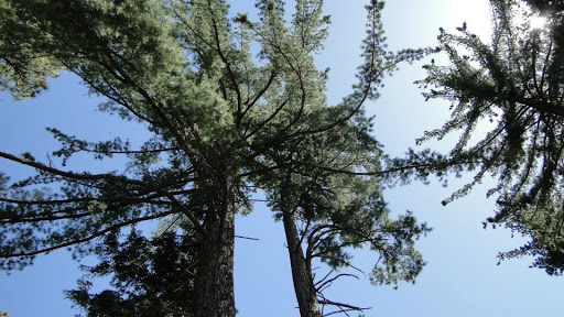
I hit the trail at 6:00 am after a two hour drive up from Oceanside. The sun hadn’t yet risen over the ridge to the east, so the forest – a mixture of pine, fir, cedar, and oak – lay in gloom. The marine layer was strong, and I could glimpse a vast sea of fog climbing up into the canyon before it reached the inversion cap at about 5,000 feet. Since the trailhead sits around 6,000, the marine layer lay directly below me, creating the impression that the clouds had swallowed up the world.
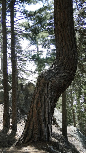
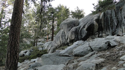
The trail begins climbing immediately and continues to do so relentlessly for the next 3.3 miles. The oaks and cedars gradually disappeared as white fir and a predominance of Ponderosa pine replaced it. Coupled with the liberal sprinklings of granitic boulders, the forest takes on a character that is decidely reminiscent of the western Sierra Nevadas.
At about 8,000 feet on an increasingly north-facing slope, snow began to appear in patches. My feelings about snow have become deeply ambivalent at this point. On one hand, I appreciate its rareness in Southern California, as well as its ability to magically transform a landscape into a silent, shrouded wonderland. On the other hand, hiking in snow is a massive pain in the ass. Normally, it simply makes your feet wet and makes you expend twice as much effort to move forward. However, on a trail traveling through a boulder-strewn, densely-forested single-track trail, snow quickly evolved from a nuisance into a serious problem.
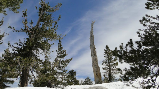
At Little Round Valley, an idyllic, generally round subalpine valley, the snow accumulation was so heavy that the trail vanished. Everything close to the PCT had been relatively heavy traveled due to a number of through-hikers having already reached San Jacinto, but the area beyond Little Round Valley leading to the peak had been little traveled since the last snow storm. Once I lost the trail in the valley, I was essentially on my own.
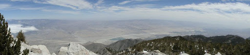
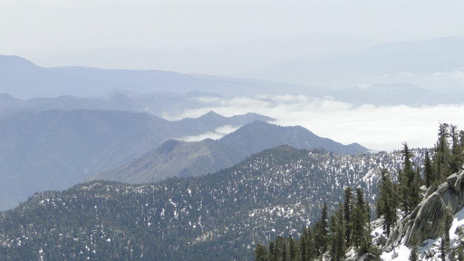
I knew roughly in which direction the peak was, and I knew from my iPhone compass and maps (and thank heaven reception is strong on this mountain, or else I would have turned back) which way I was headed, so I continued on off the trail in the direction in which I knew the summit to be. I spent the next three hours boulder hopping, treading (and sometimes sinking into) deep snow drifts, and hopping across “islands” not covered by snow until I finally reached a ridge. After I crossed this ridge, I was treated with the magnificent site of the Coachella Valley lying 8,000 feet below me.
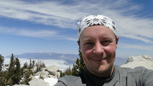
I looked to my right and saw a pile of boulders. I couldn’t believe how far and how fast I had come. I must have short-cutted the trail by about a half a mile and gained 1,000 feet by cutting almost directly up the mountainside. After another half hour of climbing boulders and sinking crotch-deep into the snow, I finally reached the top boulder. I had made it! I scanned the horizon, admiring the marvellous view. And there, about a half mile to the north and about 500 feet above me, sat the pyramid-shaped summit of the real San Jacinto.
I had scaled the wrong peak.
In my head, I heard the refrain, “You’ve only failed when you’ve given up.” I knew I had time, and I knew where I was going, so I made a beeline to the peak, crossing snow and hopping boulders. I was getting close to the peak when, miraculously, I stumbled across what was clearly a trail. The trail lead to a patch of snow that had a line of foot prints from previous hikers. I silently expressed my gratitude to all of those who came before and did my best to deepen the trail through the snow as I began the final approach to the summit.
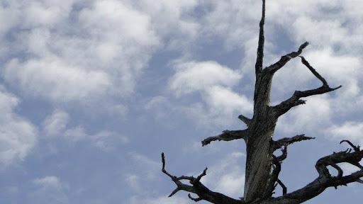
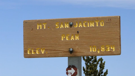
I passed the old stone emergency cabin, trudged up the last embankment of snow, and came to the sign indicating where I was: Mt. San Jacinto. Elev. 10,834 Feet. The arrow pointed to a boulder that stood above the rest. I climbed up and experienced something I had never before experienced: there was nothing above me but sky. No neighboring peak (aside from San Gorgonio, and perspective made that seem equal) and no trees. Only clouds and endless sky. I had climbed my first major mountain.
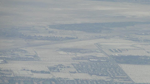
I-10 was a thin ribbon crossing a vast, beige plain. Tiny windmills spun, looking like nothing more than grains of rice on the kitchen floor. A quilt of vegetation, subdivisions, and golf courses spread for endless miles down the broad valley. San Gorgonio’s shoulders were shrouded in marine layer. The peaks stretches southeast shrank progressively, and brown hills to the north were eventually swallowed up by the atmosphere. More surreal than all of that though was the feeling of transcendence. I hadn’t just climbed up a hill; I had surpassed my previous limitations.
Mountain climbing offers a great metaphor that has been used from Sisyphus to the modern day. Everybody has their “hill to climb,” and attacking a literal hill gives you a sense of accomplishment and ability that can easily translate into other aspects of life. Tough day at the office? Well, it can’t be too much tougher than trudging through a foot of snow at 10,000 feet.
The perspective is also incredible. It gives you a sense of seeing the world as it actually is, rather than being caught in a large network of parts. From above, the world, both natural and manufactured, is clearly a living organism that, consciously or unconsciously, is living a life of its own. Every aspect of that world is revealed, and one can consider and contemplate it from one of the most isolated and expansive viewpoints imaginable. Essentially, you are outside of the world while being at the very heart of it at the same time.
The principles I gleaned from this go beyond the philosophical, however, and here is where the cautionary tail comes into play. Always know what you’re walking into. Call ahead and find out the weather conditions. I completed this hike because I had cell phone reception. Without that, I would have been hopelessly lost in a snow-covered forest at a perilously high elevation. In fact, I would have turned back long before I had the opportunity to be hopelessly lost, illustrating the second principle: know your limits. If you are attempting something beyond your scope of competency, you are very likely to fail.
All of that said, this was an incredible first experience in both the good, the bad, and the sublime. I learned a lot about mountain climbing, but I learned even more about myself, and the rare, truly great hikes experiences will always give you that gift.
May: 13.3 Miles
Year to Date: 520.6