

This weekend, I took a trip out to Anza-Borrego Desert State Park to take an overnight hike up to Whale Peak with my friends, Jim and Alex. As with any hike into Anza-Borrego, this was also an opportunity for me to re-scout a few routes (5, in this case) for a possible 6th edition. I noted a number of changes, with some of them being significant.
Cool Canyon
(No changes to this route)
This approach route to Granite Mountain is a great little hike on its own, and I hiked it as a means of killing time while waiting for everybody else to get there. I woke up at 4, and since I knew I wouldn’t be getting back to sleep, I figured I’d hope in the car and set off. I hike the 1 mile route up Cool Canyon to a confluence of three washes, and it’s at this point where the east approach to Granite Mountain begins. There wasn’t time or energy for Granite, but I did hike up about a quarter of a mile to watch the sun come up over Whale Peak.
Whale Peak, West and North Approach
(Potential significant changes to the west approach)
Jim, Alex, Sicco, and I met at Foot and Walker Pass in Blair Valley, which is the start point for the west approach to Whale Peak. We set off up the road to Little Blair Valley, continuing past Little Blair until the road’s end. From there, it’s straight up canyon until the trail joins the north approach to Whale Peak that leads from Pinyon Mountain Road. We hiked nearly the entirety of the North Approach, minus the scramble of the slope from the road, so I’m gonna go ahead and count this as a double.
The biggest changes at Whale Peak are trail condition and habitat. The trail is even more well-worn and easily identifiable now than it was in 2015 when I last scouted this area. It’s clear that hiker traffic has beat down a trail that is very easy to follow, but despite this ease, there are a number of cairns of dubious necessity. I’ve hiked maintained trails in the Sierra that are harder to follow than this route, and the numerous cairns seemed a bit redundant. I only removed the really ridiculous ones – like the five cairns stacked within 20 feet of each other on an obvious path. I’ll have more to say about the rest of them below.

The habitat at Whale Peak has been devastated by climate change. Hotter temperatures, reduced rainfall, and a nearly non-existent monsoon season has killed about 75% of the pinyons on the mountain over the last 10 years. A lot of those pinyons appear to have died recently, with many of them hanging on to a few of their brown, dead twigs. This is a huge loss for this island in the sky, and it’s yet another indicator that San Diego County’s habitats are groaning under the strain of a changing climate.

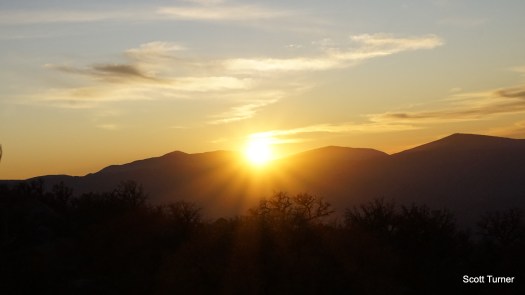
We camped atop Whale Peak at a pair of well-used campsites adjacent to the summit. Even with schlepping all of our water up to the top, this is a phenomenal place to camp. The sunset was beautiful, and the sunrise was equally beautiful. Since Whale Peak sits in the approximate center of the park, the views are comprehensive – perhaps even the best in the park.

Smugglers Canyon
Our return route followed Smugglers Canyon from the upper reaches of Whale Peak down to the Pictograph Trail. Smugglers Canyon is a delight to hike, with a number of fun bouldering challenges mixed in with a diverse mix of desert vegetation. I had been considering replacing the West Approach, which is good, but not great due to long stretches of road walking and cross-country across Little Blair Valley.
After re-hiking Smugglers Canyon downhill, I’m even more inclined to scrap the full West Approach in favor of a shorter route from the Pictographs. Smugglers Canyon itself is more enjoyable than the first half of the hike from Foot and Walker Pass, and a large part of the best section of that hike follows the North Approach. 90% chance I change this unless somebody persuades me otherwise.
Pictograph Trail
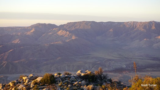
Although it would have been faster to cut over to the pictographs, we opted to follows Smugglers Canyon’s wash all the way to the Smugglers Canyon Overlook. We passed two separate groups from the Sierra Club’s Wilderness Basics Course, with one of them lounging at the overlook. This overlook has great views of the Laguna Mountains, and it’s a pleasant place to enjoy a snack.

We retraced our steps up the wash, but kept left toward the Pictographs. No changes to this section, as the Pictographs haven’t changed in any way over the last 5 years. The trail is easy to follow, and that hasn’t changed at all either.

Cairns
I first hiked Whale Peak in 2012, and although there were a number of mishaps with my car (don’t take a Civic up Pinyon Mountain Road, folks), the hike itself was a success.At the time, I had no trouble finding my way while relying on the directions in Afoot and Afield, even though there was a thick layer of snow on the ground and not a single cairn to be found.

Since then, social media and AllTrails have brought more hikers to Whale Peak, many of whom don’t read book directions nor know how to navigate without the aid of a GPS app. These hikers appear to have established a rather absurd amount of cairns while beating in the easily identifiable trail. The trail is now as easy to follow as some of the established trails in the west half of the county.
Now, anybody who’s ever heard me talk about cairns knows that I have no love for the things, but I refrained from knocking them down because I know many of the people hiking this peak would be lost without them. I know this might rub a few people the wrong way, but quite frankly, cairns are lazy. They prevent hikers from actually navigating, allowing them instead to blindly follow the rock stacks. As Alex stated on the hike, they are the “Wikipedia” of navigation; you don’t know who put them there, and you don’t know if they’re reliable. And sure enough, there are a couple of different places where the cairns actually cause confusion.
My recommendation, for what it’s worth, is that people do what the folks in the two WBC groups I met were doing: learn how to navigate. There’s no need to follow a cairn if you know how to navigate. Even if all you’re doing is following directions from a reliable source while paying attention to where you’re going and what you’re doing, you don’t need cairns in 99% of situations. The only places where cairns are necessary is where park rangers have established them to mark official, but difficult to maintain routes. They don’t belong on places like Whale Peak.
And again, the reason they’re on Whale Peak is that there are a lot of people hiking that route who don’t know how to navigate. They take the easy way out rather than learn traditional nav skills, and in doing so, they’ve left a ton of rock piles on a trail that is easy to follow 95% of the time anyway.
