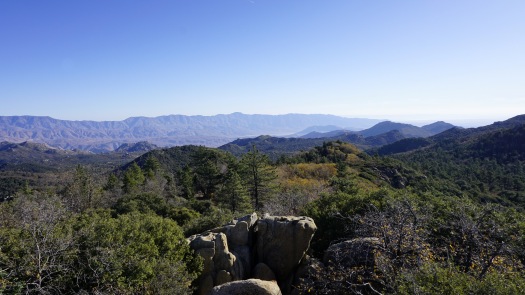
Last Sunday, I woke up with the dawn and broke like the wind to get in a solid walkabout. I initially had my eyes on a Cuyamaca walkabout, which has become my go-to for a longer, more involved hike that also features good views and a splash of fall color. But for a variety of reasons, Hot Springs Mountain, the county’s highest point, has been on the brain lately, and so I headed there.

In the past, I’ve been hesitant to hike Hot Springs Mountain. This has nothing to do with what you actually see on the hike, which includes conifer-oak forest, fantastic views, fall-color, and a county high point. My hesitancy is always founded on being a little unsure of the protocol for visiting, as the hike sits on Los Coyotes tribal land. Even after scouting Afoot and Afield, I walked away still feeling a little uncertain about what the rules are, but with a few conversations with folks intimate with the tribe’s expectations on hiking here, my hesitancy is gone.

The tribe has adopted a welcoming stance to hikers, and provided you’re willing to pay the $10 fee (per person, not per car) to enter the reservation, you are welcome to hike the mountain along with a handful of newer trails that I haven’t scouted yet. In the past, you needed to pay the fee directly to the tribal ranger, but now you can drop your fee into the slot to get an early start. That last bit is enough to make me more eager to hike here more often, as I’m an early-bird who likes to wrap up before lunch time.

Furthermore, I got some clarification on where you can and can’t hike. The tribe recommends hiking to Hot Spring Mountain via Sukat Road, which departs from the campground. The Afoot and Afield route from Nelson Camp is, sadly, closed for reasons I can’t get into. The Sukat Road is the best (but not only) route to the top, and it’s well-worth a trip.

The 10 mile, 2500′ gain hike follows Sukat Road on a steep incline into the diverse forest atop the mountain. After about 2.5 miles, there’s a junction with Hot Spring Mountain Road, at which you turn right. Signs have been erected recently to help guide hikers, as previously the junctions were unsigned and vague. This stretch of the hike is most enjoyable, as the road passes through a pleasant mixture of coniferous forest, oak woodlands, and grassy meadows before reaching the final climb up to the summit.

The old lookout tower is as dilapidated as ever, and it’s still a bad idea to try to climb it. The high point, which lies about .25 mile to the northeast of the tower, now has a couple of straps that help with a short class 3 scramble to the top. This informal trail is still unmarked and a bit vague, but even if you settle for the lookout tower (about 20-30 feet lower than the actual summit), it’s still a great destination.

All in all, this is a great hike made even more enjoyable by some clarification in rules for visiting tribal land and some signage improvements. It’s a welcome development for San Diego hikers, as it makes a beautiful spot more inviting. Also remember that your entrance fee benefits the Los Coyotes people, so always be sure to pay on your way in.
Caltopo map link:
https://caltopo.com/m/S8BB


Scott, super description of a great hike and what was obviously a great time. Made this one years ago based on the information in one of Jerry’s early books, now it’s back on my bucket list, thanks to the updated info!