

At some point, every one of us runs headlong into some kind of obstacle that we assume is insurmountable. Perhaps it’s a lack of money, a physical handicap, a time constraint, or a lack of ability. Whatever the case, this obstacle can stop us cold and discourage us into taking a hard right turn toward something completely different (and often far less interesting).
When it comes to guide booking at least, my primary obstacle has been my always own conviction that I’m not qualified to do something. When it came to writing for Modern Hiker, I harbored the conviction that, since I’ve never written formal trail descriptions before, that I probably couldn’t hack it. When it came to proposing Afoot and Afield, I thought “who am I to revise San Diego’s hiking bible? I’m a nobody.” And when it came to SEKI Project, the thing that almost stopped me dead in my tracks was my conviction that I couldn’t create maps, let alone really good maps with clear, accurate information.
In order to create maps, I would have to learn how to use Adobe Illustrator. For a novice with no experience doing any kind of digital editing and who has little to no visual arts talent, the prospect of learning how to use Illustrator proficiently enough nearly turned me away from self-publishing. If you haven’t used it, the program appears largely impenetrable with all kinds of foreign concepts, weird commands, and multitudes of layers. Even now, three weeks into playing with it, I understand maybe 10% of what the program does.
I reckoned that I couldn’t teach myself how to do it. I figured that I’d have to hold on to some theoretical future proposal that would open the door for me writing my SEKI book. Once again, I was dead wrong.
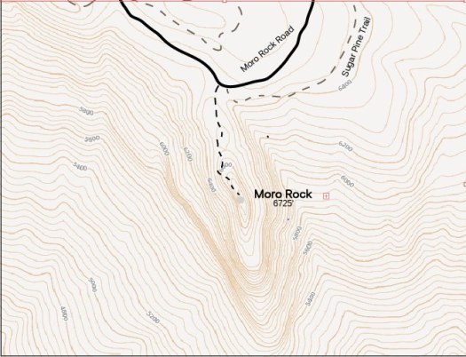
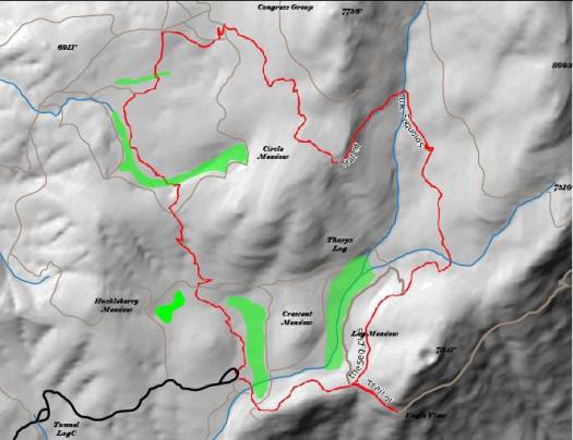
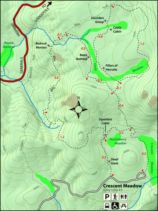
My first attempts at cartography were as crude and rudimentary as one would expect. I attempted to draw out every single individual line marking a trail, and most of my first map was little more than a bunch of enhanced relief and contour data downloaded from Caltopo.com.
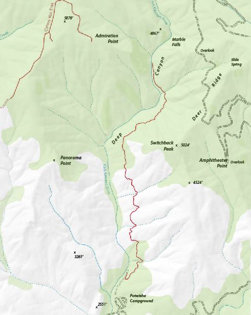
The next 8-9 attempts consisted of more elaborate and refined attempts at map making. With each attempt, I became more proficient at using specific commands. With one map, I’d master the use of the pen tool for making roads. On another map, I’d learn how to create scatter brushes to simplify trail drawings. On yet another, I would learn how to incorporate the National Park service pictographs (which are free!). I learned how to layer my base maps (USGS topos, roads, trails straight from my GPS unit, and shaded relief/contours) in an efficient manner. Finally, I learned how to separate layers so that each map component stays clean, separate, and clear; each map has about 16 layers.

With each map, my speed improved noticeably to the point where I reduced map making time from five to two hours. Each map became more refined, more organized, and more visually appealing. Now, after little over two weeks of practice, I am creating finalized versions of the maps that will go into the book. So far, I’ve completed about 5 with another 5 more needing some revision. That leaves about 90-100 maps to complete for the book.
I recognize that there are some cases where obstacles to doing whatever I set my mind to really are true. I’m not going to be an astronaut. I’m not going to be president. I’m not going to have lunch with Donald Trump. However, with most processes that require skill-building, it really is so simple as to keep practicing and to develop little micro skills that become larger skills. Eventually, the cumulative effect is that one masters a larger skill that leads to creative accomplishment.

you can do it!
Illustrator. Why did it have to be Illustrator?
I am a tried and true Photoshop guy and it’s hard to unlearn my Photoshop ways when learning Illustrator. I guess I’ll do it if I have to.
I don’t know photoshop at all. You may be able to do it. There may be enough overlap in the programs.